Planning. The best way to increase efficiency without compromising safety and the environment.
1. Download the app in the App Store (Apple iOS) or Play Store (Google Android) from your phone/tablet
What can you do with agFlier?

Save points, runways, power lines, obstacles, risk areas. And the best, share this information!

agFlier also works as a spectacular GPS navigator with an extensive database of alternative runways and warning obstacles during navigation.

Plan your application with safety and practicality. Analyze the direction of application in relation to wind direction and obstacles! Always know what is the faster and safer application direction. Increase performance without compromising safety. How many jobs you open during the season? If you optimize for the greatest number, how many flight hours you save?
Draw and measure your areas. Build multi-polygon projects for whole field. Share these areas with other users of your choice. Easily export it to SHP or KML. Navigate to the chosen area and have a graphic mapping support during application.
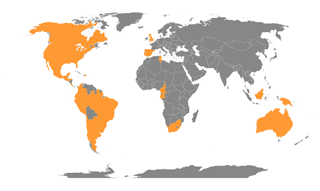
agFlier is at these countries